Energipark Hadsten Nord
Velkommen til infosiden for Energipark Hadsten Nord

Denne side viser den seneste status på projektet. Udviklingen af et VE-projekt er en dynamisk proces, hvor der løbende kan forekomme ændringer, bl.a. på baggrund af den lokale og kommunale dialog. Derfor kan projektspecifikke informationer ændre sig i løbet af udviklings- og planprocessen.
Under Tidslinje og Status kan du se de seneste opdateringer vedr. projektet.
Om Projektet
Projektets bruttoareal udgør ca. 330 ha. Projektområdet ligger i åbent land mellem Nørre Galten, Hadsten og Hadbjerg.
Projektet omfatter et jordbaseret solcelleanlæg og BESS. Det giver mulighed for opstilling af solcellemoduler svarende til en årlig strømproduktion på ca. 290.000 MWh samt et batterianlæg til lagring af den producerede energi.
Ved afgrænsning af området er der lagt vægt på at anlægget udgør en samlet enhed, og at der er sikret afstand til naboer, som ligger i umiddelbar nærhed af projektområdet.
Større sammenhæng og tilgængelighed
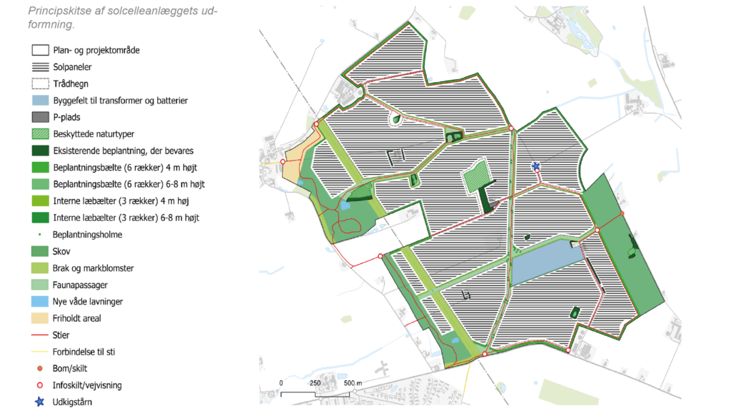
Dette er projektets foreløbige dispositionsplan. Dispositionsplanen viser de forskellige elementer indenfor projektarealet. Dispositionsplanen er udarbejdet på baggrund af lokale input, kommunal dialog samt hensyn til den interne og omkringliggende natur og miljø.
Bruttoareal
ca. 330 ha
produktion
ca. 290.000 MWh
solcelleAREAL
ca. 240 ha
læhegn
ca. 12 KM
Sti
ca. 15 KM
Ny skov
ca. 40 ha